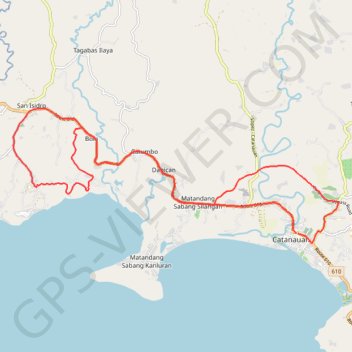
Catanauan Ikot Ride
Catanauan, Quezon (4311) Philippines Road's with Gravel Road and Untraced Map
- Distance: 34.2 Km
- Elevation gain: 358 m
- Maximum elevation: 74 m
- Elevation loss: 358 m
- Minimum elevation: 3 m
- Moving time: 1 h 56 m
- Moving speed: 17.6 Km/h
- Maximum speed: 40.6 Km/h
- Total time: 2 h 5 s
- Global speed: 17.1 Km/h
Interactive trail map
Trail profile
- Distance: 34.2 Km
- Elevation gain: 358 m
- Maximum elevation: 74 m
- Elevation loss: 358 m
- Minimum elevation: 3 m
- Moving time: 1 h 56 m
- Moving speed: 17.6 Km/h
- Maximum speed: 40.6 Km/h
- Total time: 2 h 5 s
- Global speed: 17.1 Km/h
About this trail
Name: Catanauan Ikot Ride trail, distance, elevation, map, profile, GPS track
Start: Route 610, Barangay 9, Catanauan, Quezon, Calabarzon, 4311, Philippines (13.59489 122.32400)
End: Route 610, Barangay 9, Catanauan, Quezon, Calabarzon, 4311, Philippines (13.59472 122.32443)
Coordinates: 13.59172 122.23801 13.63158 122.33674