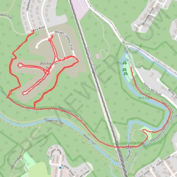
Blackwater Run connector trails on foot
- Distance: 5.6 Km
- Elevation gain: 127 m
- Maximum elevation: 217 m
- Elevation loss: 106 m
- Minimum elevation: 166 m
- Moving time: 1 h 15 m
- Moving speed: 4.4 Km/h
- Maximum speed: 11.9 Km/h
- Total time: 1 h 21 m
- Global speed: 4.1 Km/h
Interactive trail map
Trail profile
- Distance: 5.6 Km
- Elevation gain: 127 m
- Maximum elevation: 217 m
- Elevation loss: 106 m
- Minimum elevation: 166 m
- Moving time: 1 h 15 m
- Moving speed: 4.4 Km/h
- Maximum speed: 11.9 Km/h
- Total time: 1 h 21 m
- Global speed: 4.1 Km/h
About this trail
Name: Blackwater Run connector trails on foot trail, distance, elevation, map, profile, GPS track
End: Blackwater Creek Trail, Woodland, Lynchburg, Virginia, 24503, United States (37.42241 -79.16799)
Coordinates: 37.41964 -79.16799 37.42628 -79.15636