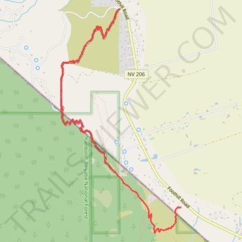
Fay-Luther-Jobs Peak Ranch Trail
- Distance: 6.4 Km
- Elevation gain: 205 m
- Maximum elevation: 1,631 m
- Elevation loss: 207 m
- Minimum elevation: 1,470 m
- Moving time: 1 h 9 m
- Moving speed: 5.5 Km/h
- Maximum speed: 8.1 Km/h
- Total time: 1 h 9 m
- Global speed: 5.5 Km/h
Interactive trail map
Trail profile
- Distance: 6.4 Km
- Elevation gain: 205 m
- Maximum elevation: 1,631 m
- Elevation loss: 207 m
- Minimum elevation: 1,470 m
- Moving time: 1 h 9 m
- Moving speed: 5.5 Km/h
- Maximum speed: 8.1 Km/h
- Total time: 1 h 9 m
- Global speed: 5.5 Km/h
About this trail
Name: Fay-Luther-Jobs Peak Ranch Trail trail, distance, elevation, map, profile, GPS track
Coordinates: 38.86698 -119.83039 38.89561 -119.81071
Other hiking, mountain biking, running and outdoor activity trails
Click on a trail to view its statistics, map and profile.
FLJPR Trail
United States > Nevada > Douglas County
Fay Luther Jobs Peak Ranch Hiking Trail
Distance: 6.0 Km • Elevation gain: 205 m • Maximum elevation: 1,631 m