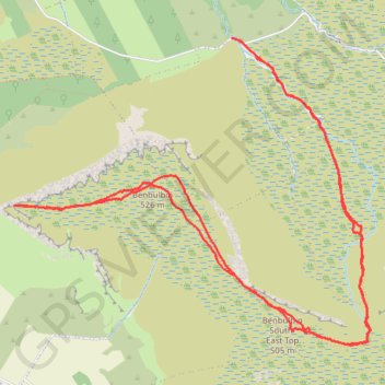
Walk to the summit of Benbulbin
Benbulban Head Walk
- Distance: 10.9 Km
- Elevation gain: 498 m
- Maximum elevation: 521 m
- Elevation loss: 501 m
- Minimum elevation: 175 m
- Moving time: 2 h 42 m
- Moving speed: 4.0 Km/h
- Maximum speed: 7.0 Km/h
- Total time: 3 h 23 m
- Global speed: 3.2 Km/h
Interactive trail map
Trail profile
- Distance: 10.9 Km
- Elevation gain: 498 m
- Maximum elevation: 521 m
- Elevation loss: 501 m
- Minimum elevation: 175 m
- Moving time: 2 h 42 m
- Moving speed: 4.0 Km/h
- Maximum speed: 7.0 Km/h
- Total time: 3 h 23 m
- Global speed: 3.2 Km/h
About this trail
Name: Walk to the summit of Benbulbin trail, distance, elevation, map, profile, GPS track
Coordinates: 54.35527 -8.48828 54.37360 -8.45194
Other hiking, mountain biking, running and outdoor activity trails
Click on a trail to view its statistics, map and profile.
CTS-N.Irelandv1.1-Belfast-Titanic>Enniscrone-via antrim coast-209miles
United Kingdom > Northern Ireland > County Down > Belfast
Distance: 335.8 Km • Elevation gain: 3,985 m • Maximum elevation: 271 m