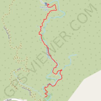
Trail Canyon Trail to Trail Canyon Falls
- Distance: 3.1 Km
- Elevation gain: 266 m
- Maximum elevation: 755 m
- Elevation loss: 66 m
- Minimum elevation: 548 m
- Moving time: 52 m 40 s
- Moving speed: 3.5 Km/h
- Maximum speed: 24.8 Km/h
- Total time: 1 h 35 m
- Global speed: 2.0 Km/h
Interactive trail map
Trail profile
- Distance: 3.1 Km
- Elevation gain: 266 m
- Maximum elevation: 755 m
- Elevation loss: 66 m
- Minimum elevation: 548 m
- Moving time: 52 m 40 s
- Moving speed: 3.5 Km/h
- Maximum speed: 24.8 Km/h
- Total time: 1 h 35 m
- Global speed: 2.0 Km/h
About this trail
Name: Trail Canyon Trail to Trail Canyon Falls trail, distance, elevation, map, profile, GPS track
End: Trail Canyon Trail, Los Angeles County, California, United States (34.32045 -118.25536)
Coordinates: 34.30533 -118.25686 34.32045 -118.25235
Other hiking, mountain biking, running and outdoor activity trails
Click on a trail to view its statistics, map and profile.
Trail Canyon Falls in Angeles National Forest
United States > California > Los Angeles County
The hike to Trail Canyon Falls in the Angeles National Forest offers a moderately challenging journey through diverse landscapes. As you traverse the trail, you'll encounter a babbling creek, verdant forests, rugged canyon walls, and enjoy views of the San Gabriel Mountains. The trail culminates at the…
Distance: 7.6 Km • Elevation gain: 366 m • Maximum elevation: 757 m