Point Lobos Loop
Point Lobos Natural Reserve offers an amazing blend of coastal beauty and wildlife, making it a perfect escape into nature. From serene coves to rocky shores, trails are well-maintained and easy to follow, with plenty of chances to spot sea otters, birds, and sea lions along the way. With sweeping Pacific views and peaceful groves of cypress and pine trees, this hike is unforgettable. #Hiking #Loop #Coast #Pacific #Ocean #Sea #Nature
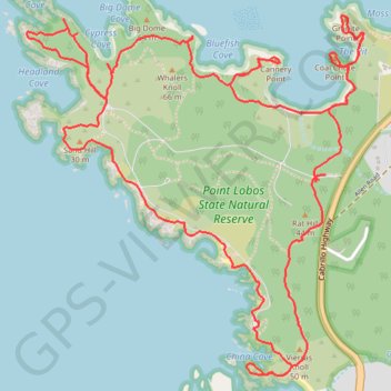
- Distance: 10.3 Km
- Elevation gain: 206 m
- Maximum elevation: 33 m
- Elevation loss: 204 m
- Minimum elevation: -1 m
- Moving time: 2 h 50 m
- Moving speed: 3.6 Km/h
- Maximum speed: 6.3 Km/h
- Total time: 3 h 57 m
- Global speed: 2.6 Km/h
Interactive trail map
Trail profile
- Distance: 10.3 Km
- Elevation gain: 206 m
- Maximum elevation: 33 m
- Elevation loss: 204 m
- Minimum elevation: -1 m
- Moving time: 2 h 50 m
- Moving speed: 3.6 Km/h
- Maximum speed: 6.3 Km/h
- Total time: 3 h 57 m
- Global speed: 2.6 Km/h
About this trail
Name: Point Lobos Loop trail, distance, elevation, map, profile, GPS track
Start: Point Lobos, Monterey County, California, 93922, United States (36.51598 -121.93782)
End: Point Lobos, Monterey County, California, 93922, United States (36.51578 -121.93815)
Coordinates: 36.50727 -121.95391 36.52292 -121.93574
Other hiking, mountain biking, running and outdoor activity trails
Click on a trail to view its statistics, map and profile.