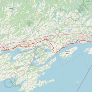
Belleville - Kingston
#Bike
- Distance: 92.7 Km
- Elevation gain: 394 m
- Maximum elevation: 115 m
- Elevation loss: 387 m
- Minimum elevation: 75 m
Interactive trail map
Trail profile
- Distance: 92.7 Km
- Elevation gain: 394 m
- Maximum elevation: 115 m
- Elevation loss: 387 m
- Minimum elevation: 75 m
About this trail
Name: Belleville - Kingston trail, distance, elevation, map, profile, GPS track
Start: 179, North Park Street, Belleville, Central Ontario, Ontario, K8P 3C4, Canada (44.18648 -77.39291)
Coordinates: 44.14085 -77.39291 44.24852 -76.50413
Other hiking, mountain biking, running and outdoor activity trails
Click on a trail to view its statistics, map and profile.
Cobourg - Belleville
Canada > Ontario > Northumberland County > Cobourg
#Bike
Distance: 81.5 Km • Elevation gain: 286 m • Maximum elevation: 118 m
Walk - Belleville Shoreline
Canada > Ontario > Belleville > Belleville
Canada, ON, Belleville
Distance: 3.8 Km • Elevation gain: 21 m • Maximum elevation: 96 m
Walk - Deseronto
Canada > Ontario > Hastings County > Deseronto
Canada, ON, Deseronto
Distance: 3.7 Km • Elevation gain: 33 m • Maximum elevation: 91 m
Zwick's Island Park
Canada > Ontario > Belleville > Belleville
Distance: 0.9 Km • Elevation gain: 5 m • Maximum elevation: 81 m