Import a GPX file

Cooloola Great Walk

Great Sandy National Park. #Hiking #Sandy

  • Distance: 88.0 Km
  • Elevation gain: 1,787 m
  • Maximum elevation: 213 m
  • Elevation loss: 1,780 m
  • Minimum elevation: 1 m

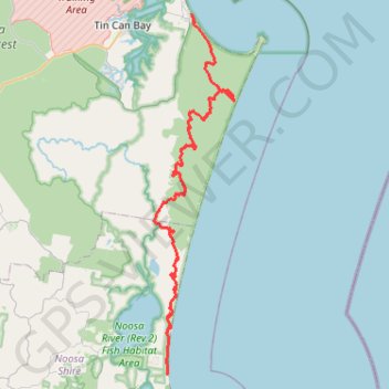
Interactive trail map

Trail profile

  • Distance: 88.0 Km
  • Elevation gain: 1,787 m
  • Maximum elevation: 213 m
  • Elevation loss: 1,780 m
  • Minimum elevation: 1 m

About this trail

Name: Cooloola Great Walk trail, distance, elevation, map, profile, GPS track

Start: Cooloola Great Walk, Noosa North Shore, Noosa Shire, Queensland, Australia (-26.32992 153.06053)

End: Wide Bay Esplanade, Rainbow Beach, Gympie Regional, Queensland, 4531, Australia (-25.90253 153.09277)

Coordinates: -26.32993 153.04349 -25.90253 153.14952

Other hiking, mountain biking, running and outdoor activity trails

Click on a trail to view its statistics, map and profile.

Rainbow Beach - Double Island Point

Australia > Queensland > Rainbow Beach

Great Sandy National Park. #MTB #Loop #Sandy

Distance: 44.4 Km • Elevation gain: 582 m • Maximum elevation: 203 m

Mount Seawah - Lake Cootharaba

Australia > Queensland

Great Sandy National Park. #Hiking #Sandy

Distance: 9.4 Km • Elevation gain: 144 m • Maximum elevation: 83 m