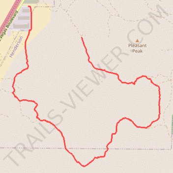
Sloan South East Loop Hike
- Distance: 8.2 Km
- Elevation gain: 172 m
- Maximum elevation: 983 m
- Elevation loss: 184 m
- Minimum elevation: 852 m
- Moving time: 1 h 36 m
- Moving speed: 5.1 Km/h
- Maximum speed: 7.8 Km/h
- Total time: 1 h 39 m
- Global speed: 4.9 Km/h
Interactive trail map
Trail profile
- Distance: 8.2 Km
- Elevation gain: 172 m
- Maximum elevation: 983 m
- Elevation loss: 184 m
- Minimum elevation: 852 m
- Moving time: 1 h 36 m
- Moving speed: 5.1 Km/h
- Maximum speed: 7.8 Km/h
- Total time: 1 h 39 m
- Global speed: 4.9 Km/h
About this trail
Name: Sloan South East Loop Hike trail, distance, elevation, map, profile, GPS track
Start: Henderson, Clark County, Nevada, United States (35.91404 -115.18888)
End: Clark County, Nevada, 89054, United States (35.91867 -115.19889)
Coordinates: 35.89443 -115.20180 35.91871 -115.17417