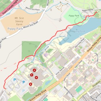
Long Pond Trail
- Distance: 2.0 Km
- Elevation gain: 47 m
- Maximum elevation: 79 m
- Elevation loss: 55 m
- Minimum elevation: 51 m
- Moving time: 23 m 43 s
- Moving speed: 5.1 Km/h
- Maximum speed: 7.6 Km/h
- Total time: 23 m 43 s
- Global speed: 5.1 Km/h
Interactive trail map
Trail profile
- Distance: 2.0 Km
- Elevation gain: 47 m
- Maximum elevation: 79 m
- Elevation loss: 55 m
- Minimum elevation: 51 m
- Moving time: 23 m 43 s
- Moving speed: 5.1 Km/h
- Maximum speed: 7.6 Km/h
- Total time: 23 m 43 s
- Global speed: 5.1 Km/h
About this trail
Name: Long Pond Trail trail, distance, elevation, map, profile, GPS track
Coordinates: 47.57032 -52.74824 47.58033 -52.73014
Other hiking, mountain biking, running and outdoor activity trails
Click on a trail to view its statistics, map and profile.
Whitbourne - St. John's
Canada > Newfoundland and Labrador > Whitbourne
#Bike #Whitbourne #StJohns #Newfoundland #Atlantic
Distance: 103.3 Km • Elevation gain: 1,230 m • Maximum elevation: 234 m