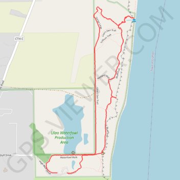
Lion's Den Trail and Bluff Trail Loop via Public Beach in Lion's Den Gorge Nature Preserve
The Lion's Den Trail and Bluff Trail Loop offers an delightful hike with striking views of Lake Michigan and tranquil forest paths. Walking along the bluffs, hikers can look out over dramatic lake vistas, often vibrant with monarch butterflies in late summer, and follow the staircase down to a secluded beach framed by towering cliffs. The trail is well-marked and features boardwalks through wetland areas, making it a scenic escape perfect for nature enthusiasts of all ages, with ample spots to pause and enjoy the view. #Hiking #Loop #Cliff #Lake #Beach #Forest #Nature
- Distance: 3.3 Km
- Elevation gain: 48 m
- Maximum elevation: 212 m
- Elevation loss: 46 m
- Minimum elevation: 178 m
- Moving time: 52 m 56 s
- Moving speed: 3.8 Km/h
- Maximum speed: 5.8 Km/h
- Total time: 1 h 2 m
- Global speed: 3.2 Km/h
Interactive trail map
Trail profile
- Distance: 3.3 Km
- Elevation gain: 48 m
- Maximum elevation: 212 m
- Elevation loss: 46 m
- Minimum elevation: 178 m
- Moving time: 52 m 56 s
- Moving speed: 3.8 Km/h
- Maximum speed: 5.8 Km/h
- Total time: 1 h 2 m
- Global speed: 3.2 Km/h
About this trail
Name: Lion's Den Trail and Bluff Trail Loop via Public Beach in Lion's Den Gorge Nature Preserve trail, distance, elevation, map, profile, GPS track
Coordinates: 43.33771 -87.88958 43.34760 -87.88242