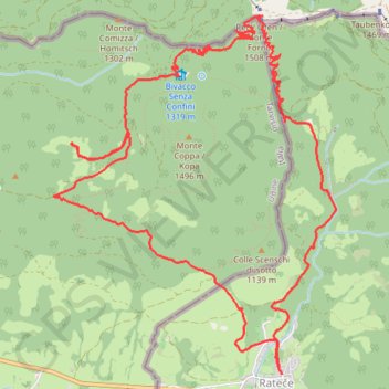
Monte Forno da Rateče SLO
- Distance: 14.3 Km
- Elevation gain: 752 m
- Maximum elevation: 1,501 m
- Elevation loss: 749 m
- Minimum elevation: 871 m
- Moving time: 3 h 58 m
- Moving speed: 3.6 Km/h
- Maximum speed: 28.0 Km/h
- Total time: 4 h 58 m
- Global speed: 2.9 Km/h
Interactive trail map
Trail profile
- Distance: 14.3 Km
- Elevation gain: 752 m
- Maximum elevation: 1,501 m
- Elevation loss: 749 m
- Minimum elevation: 871 m
- Moving time: 3 h 58 m
- Moving speed: 3.6 Km/h
- Maximum speed: 28.0 Km/h
- Total time: 4 h 58 m
- Global speed: 2.9 Km/h
About this trail
Name: Monte Forno da Rateče SLO trail, distance, elevation, map, profile, GPS track
Start: Rateče, Kranjska Gora, 4283, Slovenia (46.49818 13.71643)
End: Rateče, Kranjska Gora, 4283, Slovenia (46.49832 13.71632)
Coordinates: 46.49818 13.69329 46.52316 13.72183
Other hiking, mountain biking, running and outdoor activity trails
Click on a trail to view its statistics, map and profile.
Slovenia: Ratece - 3 borders - Ratece
Distance: 12.8 Km • Elevation gain: 729 m • Maximum elevation: 1,501 m