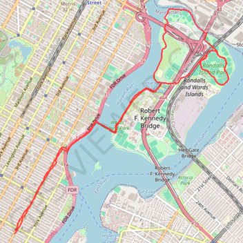
Morning Run
- Distance: 13.7 Km
- Elevation gain: 158 m
- Maximum elevation: 34 m
- Elevation loss: 162 m
- Minimum elevation: -3 m
- Moving time: 1 h 4 m
- Moving speed: 12.8 Km/h
- Maximum speed: 55.6 Km/h
- Total time: 1 h 4 m
- Global speed: 12.8 Km/h
Interactive trail map
Trail profile
- Distance: 13.7 Km
- Elevation gain: 158 m
- Maximum elevation: 34 m
- Elevation loss: 162 m
- Minimum elevation: -3 m
- Moving time: 1 h 4 m
- Moving speed: 12.8 Km/h
- Maximum speed: 55.6 Km/h
- Total time: 1 h 4 m
- Global speed: 12.8 Km/h
About this trail
Name: Morning Run trail, distance, elevation, map, profile, GPS track
Coordinates: 40.77156 -73.95322 40.80195 -73.91493
Other hiking, mountain biking, running and outdoor activity trails
Click on a trail to view its statistics, map and profile.
Old Croton Aqueduct Trail and Bronx
United States > New York > Westchester County > Village of Croton-on-Hudson
Distance: 70.8 Km • Elevation gain: 823 m • Maximum elevation: 80 m