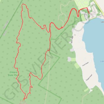
Elmore Mountain Loop
Loop hike from Lake Elmore to Elmore Mountain via Ridge Trail and Fire Tower Trail in the Elmore State Park. #Hiking #Loop #Mountain #Nature #Lake #Forest #Park
- Distance: 9.1 Km
- Elevation gain: 461 m
- Maximum elevation: 784 m
- Elevation loss: 461 m
- Minimum elevation: 353 m
- Moving time: 2 h 14 m
- Moving speed: 4.0 Km/h
- Maximum speed: 6.4 Km/h
- Total time: 2 h 31 m
- Global speed: 3.6 Km/h
Interactive trail map
Trail profile
- Distance: 9.1 Km
- Elevation gain: 461 m
- Maximum elevation: 784 m
- Elevation loss: 461 m
- Minimum elevation: 353 m
- Moving time: 2 h 14 m
- Moving speed: 4.0 Km/h
- Maximum speed: 6.4 Km/h
- Total time: 2 h 31 m
- Global speed: 3.6 Km/h
About this trail
Name: Elmore Mountain Loop trail, distance, elevation, map, profile, GPS track
Start: Beach Road, Lake Elmore, Elmore, Lamoille County, Vermont, 05657, United States (44.54239 -72.52895)
End: Beach Road, Lake Elmore, Elmore, Lamoille County, Vermont, 05657, United States (44.54241 -72.52903)
Coordinates: 44.52639 -72.54859 44.54422 -72.52895
Other hiking, mountain biking, running and outdoor activity trails
Click on a trail to view its statistics, map and profile.