Caleb Pike - Mount Finlayson - Holmes Peak
Gowlland Tod Provincial Park. #Hiking #Loop #GowllandTod
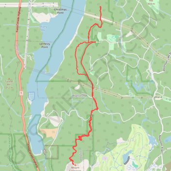
- Distance: 11.5 Km
- Elevation gain: 511 m
- Maximum elevation: 406 m
- Elevation loss: 509 m
- Minimum elevation: 171 m
Interactive trail map
Trail profile
- Distance: 11.5 Km
- Elevation gain: 511 m
- Maximum elevation: 406 m
- Elevation loss: 509 m
- Minimum elevation: 171 m
About this trail
Name: Caleb Pike - Mount Finlayson - Holmes Peak trail, distance, elevation, map, profile, GPS track
Coordinates: 48.48281 -123.54018 48.51656 -123.52965
Other hiking, mountain biking, running and outdoor activity trails
Click on a trail to view its statistics, map and profile.
Holmes Peak
Canada > British Columbia > Capital Regional District > Highlands
Gowlland Tod Provincial Park. #Hiking #GowllandTod
Distance: 2.7 Km • Elevation gain: 123 m • Maximum elevation: 313 m
Rowntree road - Jocelyn Hill
Canada > British Columbia > Capital Regional District > Highlands
Gowlland Tod Provincial Park. #Hiking #GowllandTod
Distance: 12.2 Km • Elevation gain: 524 m • Maximum elevation: 411 m
BBF loop to the Skydeck in Nanaimo
Canada > British Columbia > Cowichan Valley Regional District > Area A (Mill Bay / Malahat) > Mill Bay
BBF loop to the Skydeck
Distance: 323.5 Km • Elevation gain: 6,222 m • Maximum elevation: 706 m