Thank you for supporting this site ❤️
Make a donation
Make a donation
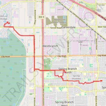
Harris County Cycling
- Distance: 24.5 Km
- Elevation gain: 33 m
- Maximum elevation: 34 m
- Elevation loss: 33 m
- Minimum elevation: 27 m
- Moving time: 1 h 23 m
- Moving speed: 17.6 Km/h
- Maximum speed: 38.1 Km/h
- Total time: 2 h 6 m
- Global speed: 11.7 Km/h
Interactive trail map
Thank you for supporting this site ❤️
Make a donation
Make a donation
Trail profile
- Distance: 24.5 Km
- Elevation gain: 33 m
- Maximum elevation: 34 m
- Elevation loss: 33 m
- Minimum elevation: 27 m
- Moving time: 1 h 23 m
- Moving speed: 17.6 Km/h
- Maximum speed: 38.1 Km/h
- Total time: 2 h 6 m
- Global speed: 11.7 Km/h
Thank you for supporting this site ❤️
Make a donation
Make a donation
About this trail
Name: Harris County Cycling trail, distance, elevation, map, profile, GPS track
Coordinates: 29.81394 -95.59241 29.85393 -95.51979
Thank you for supporting this site ❤️
Make a donation
Make a donation