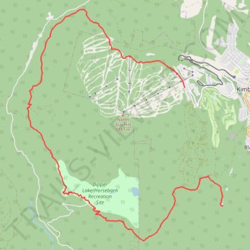
Round the North Star Mountain
- Distance: 20.1 Km
- Elevation gain: 587 m
- Maximum elevation: 1,613 m
- Elevation loss: 717 m
- Minimum elevation: 1,180 m
- Moving time: 2 h 42 m
- Moving speed: 7.4 Km/h
- Maximum speed: 38.2 Km/h
- Total time: 3 h 33 m
- Global speed: 5.6 Km/h
Interactive trail map
Trail profile
- Distance: 20.1 Km
- Elevation gain: 587 m
- Maximum elevation: 1,613 m
- Elevation loss: 717 m
- Minimum elevation: 1,180 m
- Moving time: 2 h 42 m
- Moving speed: 7.4 Km/h
- Maximum speed: 38.2 Km/h
- Total time: 3 h 33 m
- Global speed: 5.6 Km/h
About this trail
Name: Round the North Star Mountain trail, distance, elevation, map, profile, GPS track
Coordinates: 49.64490 -116.07316 49.70609 -115.99318
Other hiking, mountain biking, running and outdoor activity trails
Click on a trail to view its statistics, map and profile.
Dipper Lake/Horsebarn Nature Park Trail
Canada > British Columbia > Regional District of East Kootenay > Kimberley
Bike, trails, kimberley
Distance: 18.9 Km • Elevation gain: 578 m • Maximum elevation: 1,342 m
Bike Trails in Kimberley
Canada > British Columbia > Regional District of East Kootenay > Kimberley
Tour through the forest
Distance: 12.4 Km • Elevation gain: 302 m • Maximum elevation: 1,228 m
Bike Trails in Kimberley
Canada > British Columbia > Regional District of East Kootenay > Kimberley
Bike, Trails, Kimberley
Distance: 21.5 Km • Elevation gain: 554 m • Maximum elevation: 1,364 m
Bike trail near Kimberley
Canada > British Columbia > Regional District of East Kootenay > Kimberley
Distance: 15.7 Km • Elevation gain: 451 m • Maximum elevation: 1,381 m