Thank you for supporting this site ❤️
Make a donation
Make a donation
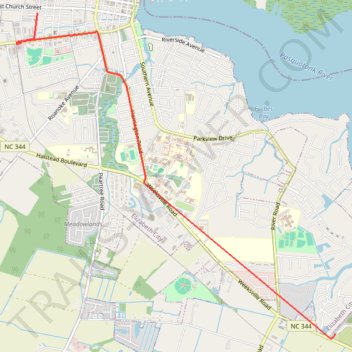
2025-12-08_06-49_Mon
- Distance: 6.7 Km
- Elevation gain: 12 m
- Maximum elevation: 5 m
- Elevation loss: 14 m
- Minimum elevation: 2 m
- Moving time: 8 m 15 s
- Moving speed: 49.0 Km/h
- Maximum speed: 50.4 Km/h
- Total time: 9 m 24 s
- Global speed: 43.0 Km/h
Interactive trail map
Thank you for supporting this site ❤️
Make a donation
Make a donation
Trail profile
- Distance: 6.7 Km
- Elevation gain: 12 m
- Maximum elevation: 5 m
- Elevation loss: 14 m
- Minimum elevation: 2 m
- Moving time: 8 m 15 s
- Moving speed: 49.0 Km/h
- Maximum speed: 50.4 Km/h
- Total time: 9 m 24 s
- Global speed: 43.0 Km/h
Thank you for supporting this site ❤️
Make a donation
Make a donation
About this trail
Name: 2025-12-08_06-49_Mon trail, distance, elevation, map, profile, GPS track
End: Pasquotank County, North Carolina, 27909, United States (36.26307 -76.19108)
Coordinates: 36.26250 -76.23491 36.29855 -76.19108
Thank you for supporting this site ❤️
Make a donation
Make a donation