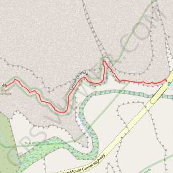
Zion Canyon Overlook
Starting near the Zion–Mount Carmel Tunnel, the Canyon Overlook Trail climbs sandstone steps and follows rocky ledges above Pine Creek’s shadowed slot canyon.
The route then winds through pale slickrock, canyon walls, desert shrubs, and sheltered alcoves, with chances to spot bighorn sheep along the way.
It finishes at a fenced cliff-edge viewpoint over lower Zion Canyon, with broad views toward the Towers of the Virgin and the park’s red-and-cream sandstone landscape.
#Hiking #Canyon #Mountain #Nature #Zion #Cliff #Rock
- Distance: 0.8 Km
- Elevation gain: 67 m
- Maximum elevation: 1,619 m
- Elevation loss: 114 m
- Minimum elevation: 1,527 m
Interactive trail map
Trail profile
- Distance: 0.8 Km
- Elevation gain: 67 m
- Maximum elevation: 1,619 m
- Elevation loss: 114 m
- Minimum elevation: 1,527 m
About this trail
Name: Zion Canyon Overlook trail, distance, elevation, map, profile, GPS track
Start: Zion-Mount Carmel Highway, Washington County, Utah, United States (37.21344 -112.94062)
End: Canyon Overlook Trail, Washington County, Utah, United States (37.21331 -112.94595)
Coordinates: 37.21264 -112.94595 37.21399 -112.94062
Other hiking, mountain biking, running and outdoor activity trails
Click on a trail to view its statistics, map and profile.
Pullout via Canyon Overlook
United States > Utah > Washington County
Distance: 3.1 Km • Elevation gain: 370 m • Maximum elevation: 1,621 m