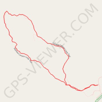
Painted Canyon Loop Trail in Theodore Roosevelt National Park
The Painted Canyon Loop Trail offers an excellent opportunity to explore the Theodore Roosevelt National Park’s striking geological features. As you hike, you'll descend into the canyon, taking in sweeping views of the colorful badlands and unique rock formations. Along the way, you may spot wildlife such as bison or prairie dogs, and the trail also leads through an area filled with juniper and pine trees, adding to the rich landscape diversity. This short, moderately challenging loop provides a great introduction to the rugged beauty of the park. #Hiking #Loop #Overlook #Canyon #Nature
- Distance: 1.4 Km
- Elevation gain: 75 m
- Maximum elevation: 847 m
- Elevation loss: 75 m
- Minimum elevation: 771 m
- Moving time: 35 m 21 s
- Moving speed: 2.4 Km/h
- Maximum speed: 3.9 Km/h
- Total time: 41 m 51 s
- Global speed: 2.0 Km/h
Interactive trail map
Trail profile
- Distance: 1.4 Km
- Elevation gain: 75 m
- Maximum elevation: 847 m
- Elevation loss: 75 m
- Minimum elevation: 771 m
- Moving time: 35 m 21 s
- Moving speed: 2.4 Km/h
- Maximum speed: 3.9 Km/h
- Total time: 41 m 51 s
- Global speed: 2.0 Km/h
About this trail
Name: Painted Canyon Loop Trail in Theodore Roosevelt National Park trail, distance, elevation, map, profile, GPS track
Start: Painted Canyon Loop Trail, Billings County, North Dakota, United States (46.89514 -103.38294)
End: Painted Canyon Loop Trail, Billings County, North Dakota, United States (46.89514 -103.38288)
Coordinates: 46.89489 -103.38856 46.89817 -103.38288