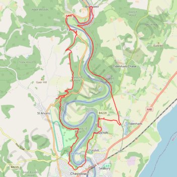
Tintern to Chepstow
- Distance: 25.1 Km
- Elevation gain: 729 m
- Maximum elevation: 224 m
- Elevation loss: 737 m
- Minimum elevation: -2 m
Interactive trail map
Trail profile
- Distance: 25.1 Km
- Elevation gain: 729 m
- Maximum elevation: 224 m
- Elevation loss: 737 m
- Minimum elevation: -2 m
About this trail
Name: Tintern to Chepstow trail, distance, elevation, map, profile, GPS track
Start: Chapel Hill, Wye Valley, Tintern, Monmouthshire, Wales, NP16 6TJ, United Kingdom (51.69772 -2.68235)
Coordinates: 51.64208 -2.69084 51.70711 -2.64932
Other hiking, mountain biking, running and outdoor activity trails
Click on a trail to view its statistics, map and profile.
Tintern to Chepstow Loop Walk
United Kingdom > Wales > Monmouthshire > Tintern > Chapel Hill
Distance: 24.2 Km • Elevation gain: 691 m • Maximum elevation: 222 m
Tintern to Chepstow via Wye Valley Railway and Tidenham Tunnel
United Kingdom > England > Gloucestershire > Forest of Dean > Brockweir
Distance: 10.9 Km • Elevation gain: 219 m • Maximum elevation: 178 m
Dean2023-311
United Kingdom > England > Oxfordshire > Oxford
Distance: 310.3 Km • Elevation gain: 3,366 m • Maximum elevation: 290 m