Tolmie Peak from Mowich Lake via Wonderland Trail and Tolmie Peak Trail
The hike to Tolmie Peak from Mowich Lake offers a rich blend of serene forest trails, vibrant alpine lakes, and sweeping panoramic views of Mount Rainier. The route begins near Mowich Lake, following the Wonderland Trail through dense, shaded woods before revealing Eunice Lake, a strikingly clear body of water surrounded by rocky outcrops and wildflower meadows in the summer. The final ascent to Tolmie Peak Lookout, though steep, rewards hikers with a stunning 360-degree vista that includes Mount Rainier's towering presence and the vast, forested valleys below. #Hiking #Mountain #Forest #Nature #Lake #Overlook
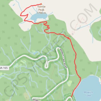
- Distance: 9.1 Km
- Elevation gain: 512 m
- Maximum elevation: 1,782 m
- Elevation loss: 513 m
- Minimum elevation: 1,505 m
Interactive trail map
Trail profile
- Distance: 9.1 Km
- Elevation gain: 512 m
- Maximum elevation: 1,782 m
- Elevation loss: 513 m
- Minimum elevation: 1,505 m
About this trail
Name: Tolmie Peak from Mowich Lake via Wonderland Trail and Tolmie Peak Trail trail, distance, elevation, map, profile, GPS track
Start: Mowich Lake Road, Pierce County, Washington, United States (46.93745 -121.86757)
End: Wonderland Trail, Pierce County, Washington, United States (46.93756 -121.86744)
Coordinates: 46.93745 -121.88409 46.95814 -121.86452
Other hiking, mountain biking, running and outdoor activity trails
Click on a trail to view its statistics, map and profile.
Northern part of the Pacific Crest Trail (PCT)
United States > Oregon > Klamath County
Hike on the Pacific Crest National Scenic Trail from Crater Lake to Canada Border through Oregon and Washington along the Sierra Nevada and Cascade mountain ranges. #Hiking #Mountain #SierraNevada #Cascade #Nature #Forest #Park #PCT
Distance: 1,198.3 Km • Elevation gain: 44,308 m • Maximum elevation: 2,307 m