Mount Healy Overlook Trail in Denali National Park
The Mount Healy Overlook Trail offers a spectacular adventure filled with stunning views and invigorating climbs. As you hike through lush spruce forests, the trail leads you to rocky overlooks where you can feast your eyes on the vast expanse of the Nenana Valley and even catch a glimpse of Denali on clear days. Despite its steep ascent, the sense of accomplishment is rewarding as you reach the open terrain with panoramic views of the surrounding peaks, making it a must-visit for hiking enthusiasts. #Hiking #Mountain #Forest #Nature
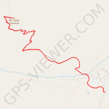
- Distance: 8.1 Km
- Elevation gain: 535 m
- Maximum elevation: 1,064 m
- Elevation loss: 534 m
- Minimum elevation: 536 m
- Moving time: 1 h 41 m
- Moving speed: 4.8 Km/h
- Maximum speed: 11.5 Km/h
- Total time: 1 h 44 m
- Global speed: 4.7 Km/h
Interactive trail map
Trail profile
- Distance: 8.1 Km
- Elevation gain: 535 m
- Maximum elevation: 1,064 m
- Elevation loss: 534 m
- Minimum elevation: 536 m
- Moving time: 1 h 41 m
- Moving speed: 4.8 Km/h
- Maximum speed: 11.5 Km/h
- Total time: 1 h 44 m
- Global speed: 4.7 Km/h
About this trail
Name: Mount Healy Overlook Trail in Denali National Park trail, distance, elevation, map, profile, GPS track
Start: Denali Park Road, Denali, Alaska, United States (63.73056 -148.91906)
End: Taiga Loop, Denali, Alaska, United States (63.73041 -148.91923)
Coordinates: 63.73041 -148.95595 63.74276 -148.91906
Other hiking, mountain biking, running and outdoor activity trails
Click on a trail to view its statistics, map and profile.
Road Trip Alaska 2018
United States > Alaska > Anchorage
From Anchorage.
Distance: 641.7 Km • Elevation gain: 4,791 m • Maximum elevation: 739 m