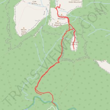
Castle Walking Track and Castle to Monolith Valley
- Distance: 15.5 Km
- Elevation gain: 1,282 m
- Maximum elevation: 852 m
- Elevation loss: 1,360 m
- Minimum elevation: 77 m
- Moving time: 5 h 40 m
- Moving speed: 2.7 Km/h
- Maximum speed: 9.4 Km/h
- Total time: 10 h 9 m
- Global speed: 1.5 Km/h
Interactive trail map
Trail profile
- Distance: 15.5 Km
- Elevation gain: 1,282 m
- Maximum elevation: 852 m
- Elevation loss: 1,360 m
- Minimum elevation: 77 m
- Moving time: 5 h 40 m
- Moving speed: 2.7 Km/h
- Maximum speed: 9.4 Km/h
- Total time: 10 h 9 m
- Global speed: 1.5 Km/h
About this trail
Name: Castle Walking Track and Castle to Monolith Valley trail, distance, elevation, map, profile, GPS track
Coordinates: -35.31915 150.18063 -35.27955 150.19980
Other hiking, mountain biking, running and outdoor activity trails
Click on a trail to view its statistics, map and profile.
Byangee Mountain and Pickering Point - Morton National Park
Distance: 18.0 Km • Elevation gain: 1,560 m • Maximum elevation: 515 m