Thank you for supporting this site ❤️
Make a donation
Make a donation
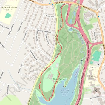
2026-06-21_13-26_Sun
- Distance: 1.6 Km
- Elevation gain: 16 m
- Maximum elevation: 54 m
- Elevation loss: 18 m
- Minimum elevation: 38 m
- Moving time: 18 m 59 s
- Moving speed: 5.1 Km/h
- Maximum speed: 6.4 Km/h
- Total time: 18 m 59 s
- Global speed: 5.1 Km/h
Interactive trail map
Thank you for supporting this site ❤️
Make a donation
Make a donation
Trail profile
- Distance: 1.6 Km
- Elevation gain: 16 m
- Maximum elevation: 54 m
- Elevation loss: 18 m
- Minimum elevation: 38 m
- Moving time: 18 m 59 s
- Moving speed: 5.1 Km/h
- Maximum speed: 6.4 Km/h
- Total time: 18 m 59 s
- Global speed: 5.1 Km/h
Thank you for supporting this site ❤️
Make a donation
Make a donation
About this trail
Name: 2026-06-21_13-26_Sun trail, distance, elevation, map, profile, GPS track
Coordinates: 40.94593 -73.80425 40.95531 -73.80083
Thank you for supporting this site ❤️
Make a donation
Make a donation
Other hiking, mountain biking, running and outdoor activity trails
Click on a trail to view its statistics, map and profile.
Eastchester, walk around lake in Twin Lakes Park
United States > New York > Westchester County > Town of Eastchester
Distance: 7.3 Km • Elevation gain: 47 m • Maximum elevation: 53 m
Bronx River Pathway
United States > New York > Westchester County > City of Yonkers
Distance: 22.2 Km • Elevation gain: 154 m • Maximum elevation: 56 m
Twin Lakes Park trails
United States > New York > Westchester County > Town of Eastchester
Distance: 10.0 Km • Elevation gain: 79 m • Maximum elevation: 54 m
Thank you for supporting this site ❤️
Make a donation
Make a donation