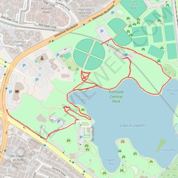
Walk in Fremont Central Park
- Distance: 4.4 Km
- Elevation gain: 15 m
- Maximum elevation: 22 m
- Elevation loss: 17 m
- Minimum elevation: 12 m
- Moving time: 44 m 47 s
- Moving speed: 5.8 Km/h
- Maximum speed: 8.5 Km/h
- Total time: 45 m 27 s
- Global speed: 5.8 Km/h
Interactive trail map
Trail profile
- Distance: 4.4 Km
- Elevation gain: 15 m
- Maximum elevation: 22 m
- Elevation loss: 17 m
- Minimum elevation: 12 m
- Moving time: 44 m 47 s
- Moving speed: 5.8 Km/h
- Maximum speed: 8.5 Km/h
- Total time: 45 m 27 s
- Global speed: 5.8 Km/h
About this trail
Name: Walk in Fremont Central Park trail, distance, elevation, map, profile, GPS track
Start: Stevenson Boulevard, Fremont, Alameda County, California, 94536, United States (37.54940 -121.97200)
End: Stevenson Boulevard, Fremont, Alameda County, California, 94536, United States (37.55365 -121.96418)
Coordinates: 37.54747 -121.97200 37.55397 -121.95859