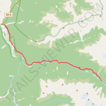
Copland Track to Welcome Flat Hut
- Distance: 17.5 Km
- Elevation gain: 835 m
- Maximum elevation: 481 m
- Elevation loss: 453 m
- Minimum elevation: 46 m
- Moving time: 6 h 31 m
- Moving speed: 2.7 Km/h
- Maximum speed: 5.5 Km/h
- Total time: 7 h 50 m
- Global speed: 2.2 Km/h
Interactive trail map
Trail profile
- Distance: 17.5 Km
- Elevation gain: 835 m
- Maximum elevation: 481 m
- Elevation loss: 453 m
- Minimum elevation: 46 m
- Moving time: 6 h 31 m
- Moving speed: 2.7 Km/h
- Maximum speed: 5.5 Km/h
- Total time: 7 h 50 m
- Global speed: 2.2 Km/h
About this trail
Name: Copland Track to Welcome Flat Hut trail, distance, elevation, map, profile, GPS track
End: Welcome Flat Hut, Copland Track, Westland District, West Coast, New Zealand (-43.63049 169.94662)
Coordinates: -43.63049 169.81173 -43.57472 169.94662
Other hiking, mountain biking, running and outdoor activity trails
Click on a trail to view its statistics, map and profile.