Church Stretton to Bridges
- Distance: 15.4 Km
- Elevation gain: 410 m
- Maximum elevation: 512 m
- Elevation loss: 354 m
- Minimum elevation: 196 m
- Moving time: 4 h 31 m
- Moving speed: 3.4 Km/h
- Maximum speed: 5.7 Km/h
- Total time: 5 h 36 m
- Global speed: 2.7 Km/h
Interactive trail map
Trail profile
- Distance: 15.4 Km
- Elevation gain: 410 m
- Maximum elevation: 512 m
- Elevation loss: 354 m
- Minimum elevation: 196 m
- Moving time: 4 h 31 m
- Moving speed: 3.4 Km/h
- Maximum speed: 5.7 Km/h
- Total time: 5 h 36 m
- Global speed: 2.7 Km/h
About this trail
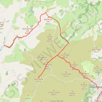
Name: Church Stretton to Bridges trail, distance, elevation, map, profile, GPS track
End: Bridges, Ratlinghope, Shropshire, England, SY5 0ST, United Kingdom (52.56254 -2.89640)
Coordinates: 52.53776 -2.89655 52.58156 -2.80779
Other hiking, mountain biking, running and outdoor activity trails
Click on a trail to view its statistics, map and profile.
Bridges to Bishops Castle
United Kingdom > England > Shropshire > Bridges
Distance: 18.9 Km • Elevation gain: 548 m • Maximum elevation: 527 m