Thank you for supporting this site ❤️
Make a donation
Make a donation
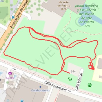
Parque Santurce footpath
- Distance: 0.9 Km
- Elevation gain: 13 m
- Maximum elevation: 24 m
- Elevation loss: 11 m
- Minimum elevation: 16 m
- Moving time: 13 m 21 s
- Moving speed: 4.0 Km/h
- Maximum speed: 7.6 Km/h
- Total time: 41 m 26 s
- Global speed: 1.3 Km/h
Interactive trail map
Thank you for supporting this site ❤️
Make a donation
Make a donation
Trail profile
- Distance: 0.9 Km
- Elevation gain: 13 m
- Maximum elevation: 24 m
- Elevation loss: 11 m
- Minimum elevation: 16 m
- Moving time: 13 m 21 s
- Moving speed: 4.0 Km/h
- Maximum speed: 7.6 Km/h
- Total time: 41 m 26 s
- Global speed: 1.3 Km/h
Thank you for supporting this site ❤️
Make a donation
Make a donation
About this trail
Name: Parque Santurce footpath trail, distance, elevation, map, profile, GPS track
Coordinates: 18.44698 -66.06732 18.44785 -66.06552
Thank you for supporting this site ❤️
Make a donation
Make a donation