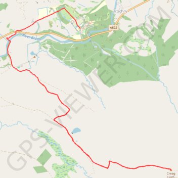
Walk up to Creag Liath
- Distance: 10.9 Km
- Elevation gain: 267 m
- Maximum elevation: 419 m
- Elevation loss: 305 m
- Minimum elevation: 180 m
- Moving time: 2 h 51 m
- Moving speed: 3.8 Km/h
- Maximum speed: 11.3 Km/h
- Total time: 3 h 45 m
- Global speed: 2.9 Km/h
Interactive trail map
Trail profile
- Distance: 10.9 Km
- Elevation gain: 267 m
- Maximum elevation: 419 m
- Elevation loss: 305 m
- Minimum elevation: 180 m
- Moving time: 2 h 51 m
- Moving speed: 3.8 Km/h
- Maximum speed: 11.3 Km/h
- Total time: 3 h 45 m
- Global speed: 2.9 Km/h
About this trail
Name: Walk up to Creag Liath trail, distance, elevation, map, profile, GPS track
Start: Trochry, Perth and Kinross, Scotland, PH8 0ED, United Kingdom (56.52993 -3.68464)
Coordinates: 56.51670 -3.69447 56.54167 -3.64844
Other hiking, mountain biking, running and outdoor activity trails
Click on a trail to view its statistics, map and profile.
Walk up Drumour and down Tombane
United Kingdom > Scotland > Perth and Kinross > Trochry
Distance: 9.3 Km • Elevation gain: 234 m • Maximum elevation: 360 m