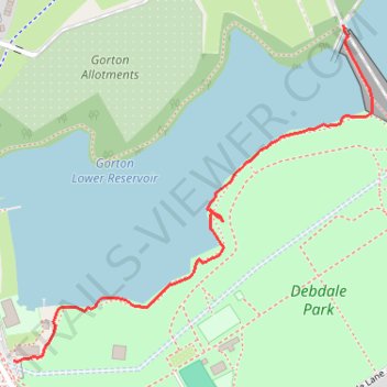
Southern shoreline path of Gorton Lower Reservoir
- Distance: 0.9 Km
- Elevation gain: 16 m
- Maximum elevation: 82 m
- Elevation loss: 15 m
- Minimum elevation: 75 m
- Moving time: 12 m 30 s
- Moving speed: 4.4 Km/h
- Maximum speed: 17.8 Km/h
- Total time: 12 m 30 s
- Global speed: 4.4 Km/h
Interactive trail map
Trail profile
- Distance: 0.9 Km
- Elevation gain: 16 m
- Maximum elevation: 82 m
- Elevation loss: 15 m
- Minimum elevation: 75 m
- Moving time: 12 m 30 s
- Moving speed: 4.4 Km/h
- Maximum speed: 17.8 Km/h
- Total time: 12 m 30 s
- Global speed: 4.4 Km/h
About this trail
Name: Southern shoreline path of Gorton Lower Reservoir trail, distance, elevation, map, profile, GPS track
Coordinates: 53.45942 -2.16089 53.46360 -2.15343
Other hiking, mountain biking, running and outdoor activity trails
Click on a trail to view its statistics, map and profile.
Morning Run
United Kingdom > England > Manchester
Distance: 10.5 Km • Elevation gain: 54 m • Maximum elevation: 99 m
Gorton Parks Loop
United Kingdom > England > Manchester
Distance: 2.7 Km • Elevation gain: 15 m • Maximum elevation: 88 m
Gorton Loop
United Kingdom > England > Manchester
Distance: 9.8 Km • Elevation gain: 53 m • Maximum elevation: 100 m
Gorton Lower Reservoir Loop
United Kingdom > England > Manchester
Distance: 2.0 Km • Elevation gain: 21 m • Maximum elevation: 87 m
Debdale Park
United Kingdom > England > Manchester
Distance: 2.0 Km • Elevation gain: 27 m • Maximum elevation: 88 m