Thank you for supporting this site ❤️
Make a donation
Make a donation
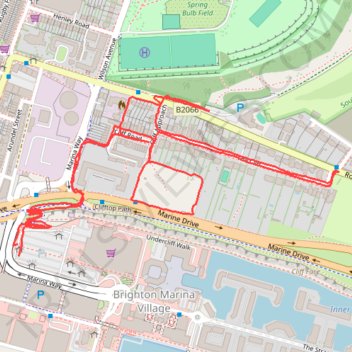
Roedean OSM
- Distance: 3.4 Km
- Elevation gain: 89 m
- Maximum elevation: 55 m
- Elevation loss: 90 m
- Minimum elevation: 4 m
- Moving time: 53 m 22 s
- Moving speed: 3.8 Km/h
- Maximum speed: 9.1 Km/h
- Total time: 58 m 15 s
- Global speed: 3.5 Km/h
Interactive trail map
Thank you for supporting this site ❤️
Make a donation
Make a donation
Trail profile
- Distance: 3.4 Km
- Elevation gain: 89 m
- Maximum elevation: 55 m
- Elevation loss: 90 m
- Minimum elevation: 4 m
- Moving time: 53 m 22 s
- Moving speed: 3.8 Km/h
- Maximum speed: 9.1 Km/h
- Total time: 58 m 15 s
- Global speed: 3.5 Km/h
Thank you for supporting this site ❤️
Make a donation
Make a donation
About this trail
Name: Roedean OSM trail, distance, elevation, map, profile, GPS track
Coordinates: 50.81358 -0.10658 50.81665 -0.09671
Thank you for supporting this site ❤️
Make a donation
Make a donation