Brandywine Falls and Brandywine Gorge Loop from Stanford House in Cuyahoga Valley National Park
The Brandywine Falls and Brandywine Gorge Loop hike offers a delightful experience, showcasing the stunning Brandywine Falls as the centerpiece of the route. Along the trail, hikers can enjoy scenic views of the gorge and the surrounding lush forests, making it particularly beautiful during the spring and autumn seasons. The trail features well-maintained paths and observation decks, allowing for easy access to various viewpoints of the waterfall, which cascades dramatically down rocky cliffs. #Hiking #Loop #Waterfall #Forest #Nature
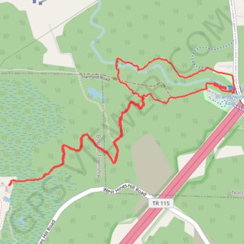
- Distance: 5.8 Km
- Elevation gain: 129 m
- Maximum elevation: 261 m
- Elevation loss: 129 m
- Minimum elevation: 203 m
- Moving time: 1 h 21 m
- Moving speed: 4.3 Km/h
- Maximum speed: 6.3 Km/h
- Total time: 1 h 25 m
- Global speed: 4.1 Km/h
Interactive trail map
Trail profile
- Distance: 5.8 Km
- Elevation gain: 129 m
- Maximum elevation: 261 m
- Elevation loss: 129 m
- Minimum elevation: 203 m
- Moving time: 1 h 21 m
- Moving speed: 4.3 Km/h
- Maximum speed: 6.3 Km/h
- Total time: 1 h 25 m
- Global speed: 4.1 Km/h
About this trail
Name: Brandywine Falls and Brandywine Gorge Loop from Stanford House in Cuyahoga Valley National Park trail, distance, elevation, map, profile, GPS track
Start: Stanford Trail, Boston Township, Summit County, Ohio, 44264, United States (41.27111 -81.55589)
End: Stanford Trail, Boston Township, Summit County, Ohio, 44264, United States (41.27109 -81.55587)
Coordinates: 41.27109 -81.55589 41.27866 -81.53812
Other hiking, mountain biking, running and outdoor activity trails
Click on a trail to view its statistics, map and profile.
Brandywine Gorge Loop Trail in Cuyahoga Valley National Park
United States > Ohio > Summit County
The Brandywine Gorge Loop Trail offers a delightful hiking experience, highlighted by scenic views of Brandywine Falls and the surrounding gorge. The trail features a mix of boardwalks and dirt paths that lead through lush greenery, past intriguing rock formations, and alongside the serene waters of Brandywine…
Distance: 2.4 Km • Elevation gain: 55 m • Maximum elevation: 261 m
Brandywine Falls and Gorge Loop via Stanford Trail in Cuyahoga Valley National Park
United States > Ohio > Summit County
The Brandywine Gorge Loop via the Stanford Trail offers hikers a journey through lush forests, leading to the impressive Brandywine Falls, where water cascades over layered sandstone cliffs. As the trail descends into the gorge, visitors are treated to views of Brandywine Creek, surrounded by moss-covered…
Distance: 5.9 Km • Elevation gain: 151 m • Maximum elevation: 261 m