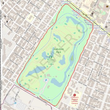
Audubon Park Loop in New Orleans
Audubon Park Loop offers a serene escape within the city's vibrant atmosphere. As you stroll along the paved path, you’ll be surrounded by majestic live oak trees, tranquil lagoons, and picturesque bridges, making it an ideal spot for leisurely walks or invigorating runs. The loop is not only a scenic route but also a vibrant wildlife habitat, providing opportunities for birdwatching and photography amid the lush greenery. #Hiking #Loop #Forest #Nature #City
- Distance: 3.2 Km
- Elevation gain: 5 m
- Maximum elevation: 9 m
- Elevation loss: 5 m
- Minimum elevation: 5 m
- Moving time: 16 m 40 s
- Moving speed: 11.7 Km/h
- Maximum speed: 22.3 Km/h
- Total time: 16 m 40 s
- Global speed: 11.7 Km/h
Interactive trail map
Trail profile
- Distance: 3.2 Km
- Elevation gain: 5 m
- Maximum elevation: 9 m
- Elevation loss: 5 m
- Minimum elevation: 5 m
- Moving time: 16 m 40 s
- Moving speed: 11.7 Km/h
- Maximum speed: 22.3 Km/h
- Total time: 16 m 40 s
- Global speed: 11.7 Km/h
About this trail
Name: Audubon Park Loop in New Orleans trail, distance, elevation, map, profile, GPS track
Coordinates: 29.92433 -90.13161 29.93567 -90.12184