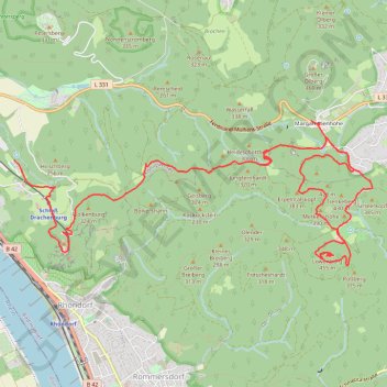
2021-01-16 14:02
- Distance: 13.7 Km
- Elevation gain: 546 m
- Maximum elevation: 425 m
- Elevation loss: 363 m
- Minimum elevation: 139 m
- Moving time: 3 h 8 m
- Moving speed: 4.3 Km/h
- Maximum speed: 40.6 Km/h
- Total time: 4 h 2 m
- Global speed: 3.4 Km/h
Interactive trail map
Trail profile
- Distance: 13.7 Km
- Elevation gain: 546 m
- Maximum elevation: 425 m
- Elevation loss: 363 m
- Minimum elevation: 139 m
- Moving time: 3 h 8 m
- Moving speed: 4.3 Km/h
- Maximum speed: 40.6 Km/h
- Total time: 4 h 2 m
- Global speed: 3.4 Km/h
About this trail
Name: 2021-01-16 14:02 trail, distance, elevation, map, profile, GPS track
Coordinates: 50.66291 7.20273 50.67697 7.25719
Other hiking, mountain biking, running and outdoor activity trails
Click on a trail to view its statistics, map and profile.
Track vom: 2020-06-13 07:00
Germany > North Rhine-Westphalia > Kreis Wesel > Schermbeck
Distance: 679.9 Km • Elevation gain: 5,301 m • Maximum elevation: 921 m
Track vom: 2020-06-27 07:26
Germany > Bavaria > Landkreis Ostallgäu > Halblech
Distance: 688.1 Km • Elevation gain: 4,307 m • Maximum elevation: 911 m
Riethoven naar Oostenrijk
Netherlands > North Brabant > Riethoven > Eind
Distance: 922.1 Km • Elevation gain: 13,629 m • Maximum elevation: 1,897 m
Eurovelo 15 - Strasbourg Rotterdam
France > Grand Est > Bas-Rhin > Strasbourg
Distance: 891.7 Km • Elevation gain: 2,104 m • Maximum elevation: 146 m
PT23BS1 Kiel → Lörrach
Germany > Schleswig-Holstein > Kiel
Distance: 1,046.7 Km • Elevation gain: 9,265 m • Maximum elevation: 757 m