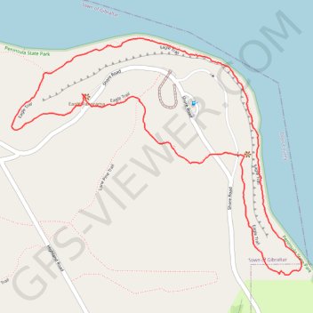
Eagle Loop Trail in Peninsula State Park
The Eagle Loop Trail offers a captivating hiking experience characterized by its rugged terrain and stunning views. As you traverse the trail, you'll encounter towering limestone bluffs, lush cedar forests, and breathtaking panoramas of Green Bay, including glimpses of Horseshoe Island. The path is lined with vibrant wildflowers and features unique geological formations, making it a rewarding adventure for those willing to navigate its challenging rocky surfaces. #Hiking #Loop #Cliff #Rock #Lake #Forest #Nature
- Distance: 3.4 Km
- Elevation gain: 94 m
- Maximum elevation: 240 m
- Elevation loss: 93 m
- Minimum elevation: 175 m
- Moving time: 1 h 21 s
- Moving speed: 3.4 Km/h
- Maximum speed: 5.5 Km/h
- Total time: 1 h 4 m
- Global speed: 3.2 Km/h
Interactive trail map
Trail profile
- Distance: 3.4 Km
- Elevation gain: 94 m
- Maximum elevation: 240 m
- Elevation loss: 93 m
- Minimum elevation: 175 m
- Moving time: 1 h 21 s
- Moving speed: 3.4 Km/h
- Maximum speed: 5.5 Km/h
- Total time: 1 h 4 m
- Global speed: 3.2 Km/h
About this trail
Name: Eagle Loop Trail in Peninsula State Park trail, distance, elevation, map, profile, GPS track
Coordinates: 45.15633 -87.20512 45.16383 -87.19207