2023-05-27 16:29
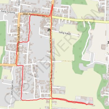
<p>Startidő: 10:31 2023. máj. 27.<br/>Célidő: 12:41 2023. máj. 27.<br/>Távolság: 3,4 km (02:10)<br/>Mozgási idő: 00:53<br/>Átlagsebeség: 1,55 km/h<br/>Mozgás átlagsebesség: 3,77 km/h<br/>Max. sebesség: 11,22 km/h<br/>Minimum magasság: 140 m<br/>Maximum magasság: 165 m<br/>Emelkedési sebesség: 81 m/h<br/>Esési sebesség: -64,4 m/h<br/>Emelkedés: 69 m<br/>Magasság csökkenés: -73 m<br/>Emelkedési idő: 00:51<br/>Esési idő: 01:08<br/></p><hr align="center" width="480" style="height: 2px; width: 517px"/>
- Distance: 3.4 Km
- Elevation gain: 20 m
- Maximum elevation: 154 m
- Elevation loss: 24 m
- Minimum elevation: 132 m
- Moving time: 1 h 29 m
- Moving speed: 2.3 Km/h
- Maximum speed: 7.4 Km/h
- Total time: 2 h 10 m
- Global speed: 1.6 Km/h
Interactive trail map
Trail profile
- Distance: 3.4 Km
- Elevation gain: 20 m
- Maximum elevation: 154 m
- Elevation loss: 24 m
- Minimum elevation: 132 m
- Moving time: 1 h 29 m
- Moving speed: 2.3 Km/h
- Maximum speed: 7.4 Km/h
- Total time: 2 h 10 m
- Global speed: 1.6 Km/h
About this trail
Name: 2023-05-27 16:29 trail, distance, elevation, map, profile, GPS track
Coordinates: -8.54921 115.25891 -8.54017 115.26587