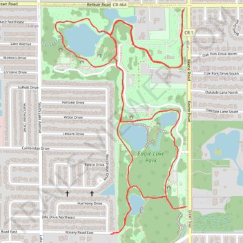
Walked the entire main cycleway of Eagle Lake park
- Distance: 6.3 Km
- Elevation gain: 12 m
- Maximum elevation: 17 m
- Elevation loss: 12 m
- Minimum elevation: 7 m
- Moving time: 1 h 12 m
- Moving speed: 5.3 Km/h
- Maximum speed: 6.3 Km/h
- Total time: 1 h 48 m
- Global speed: 3.5 Km/h
Interactive trail map
Trail profile
- Distance: 6.3 Km
- Elevation gain: 12 m
- Maximum elevation: 17 m
- Elevation loss: 12 m
- Minimum elevation: 7 m
- Moving time: 1 h 12 m
- Moving speed: 5.3 Km/h
- Maximum speed: 6.3 Km/h
- Total time: 1 h 48 m
- Global speed: 3.5 Km/h
About this trail
Name: Walked the entire main cycleway of Eagle Lake park trail, distance, elevation, map, profile, GPS track
Start: Belleair Road, Largo, Pinellas County, Florida, 33771, United States (27.93853 -82.76274)
End: Belleair Road, Largo, Pinellas County, Florida, 33771, United States (27.93848 -82.76280)
Coordinates: 27.92748 -82.76990 27.93853 -82.76257