Thank you for supporting this site ❤️
Make a donation
Make a donation
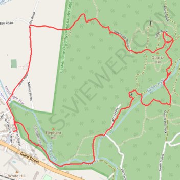
Quartz Hill, Quartz Hill mine, sailors Gully and Goldfields Track
- Distance: 7.2 Km
- Elevation gain: 132 m
- Maximum elevation: 393 m
- Elevation loss: 131 m
- Minimum elevation: 297 m
- Moving time: 1 h 17 m
- Moving speed: 5.6 Km/h
- Maximum speed: 20.6 Km/h
- Total time: 1 h 19 m
- Global speed: 5.4 Km/h
Interactive trail map
Thank you for supporting this site ❤️
Make a donation
Make a donation
Trail profile
- Distance: 7.2 Km
- Elevation gain: 132 m
- Maximum elevation: 393 m
- Elevation loss: 131 m
- Minimum elevation: 297 m
- Moving time: 1 h 17 m
- Moving speed: 5.6 Km/h
- Maximum speed: 20.6 Km/h
- Total time: 1 h 19 m
- Global speed: 5.4 Km/h
Thank you for supporting this site ❤️
Make a donation
Make a donation
About this trail
Name: Quartz Hill, Quartz Hill mine, sailors Gully and Goldfields Track trail, distance, elevation, map, profile, GPS track
Start: 11, Wallace Street, Wesley Hill, Castlemaine, Victoria, 3450, Australia (-37.07328 144.24015)
End: 11, Wallace Street, Wesley Hill, Castlemaine, Victoria, 3450, Australia (-37.07331 144.24004)
Coordinates: -37.07636 144.23932 -37.06270 144.25804
Thank you for supporting this site ❤️
Make a donation
Make a donation
Other hiking, mountain biking, running and outdoor activity trails
Click on a trail to view its statistics, map and profile.
Garfield Water Wheel, Garfield mine, Quartz Hill and Goldfields track walk
Distance: 9.9 Km • Elevation gain: 261 m • Maximum elevation: 413 m
Quartz Hill, Garfield WW and Goldfields Track walk
Australia > Victoria > Castlemaine
Distance: 7.9 Km • Elevation gain: 147 m • Maximum elevation: 393 m
Specimen Gully, Pineys, Golden Point Res, Garfield Water Wheel, Chewton, Castlemaine, Botanic gardens walk
Distance: 18.3 Km • Elevation gain: 269 m • Maximum elevation: 468 m