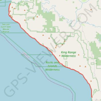
Lost Coast Trail
From Mattole Beach, the Lost Coast Trail begins on an open Pacific shoreline where sand, dunes, driftwood and low coastal vegetation lead south toward Windy Point, the Punta Gorda Light area, Cooskie Creek and Randall Creek, with the King Range rising close behind the beach and giving the route its remote, land-meets-ocean character.
Past Randall Creek, the route continues through Spanish Flat, Kinsey Creek, Big Creek and Miller Flat, where the scenery shifts between grassy coastal terraces, cobble beaches, creek mouths, surf lines, scattered camps and broad views of the undeveloped shoreline, often accompanied by signs of marine life and seabirds.
The southern section carries on past Shipman Creek, Buck Creek, Gitchell Creek and Horse Mountain Creek before arriving at Black Sands Beach near Shelter Cove, finishing with dark beach, rugged bluffs, forested slopes above the coast and the persistent contrast between the open Pacific and the steep wilderness interior of the King Range.
#Hiking #Coast #Sea #Pacific #Ocean #Nature #Mountain #Wilderness
- Distance: 41.8 Km
- Elevation gain: 718 m
- Maximum elevation: 53 m
- Elevation loss: 699 m
- Minimum elevation: -1 m
Interactive trail map
Trail profile
- Distance: 41.8 Km
- Elevation gain: 718 m
- Maximum elevation: 53 m
- Elevation loss: 699 m
- Minimum elevation: -1 m
About this trail
Name: Lost Coast Trail trail, distance, elevation, map, profile, GPS track
Start: Lost Coast Trail, Humboldt County, California, United States (40.28893 -124.35630)
End: Beach Road, Humboldt County, California, 95589, United States (40.04545 -124.07757)
Coordinates: 40.04494 -124.36338 40.28942 -124.07697