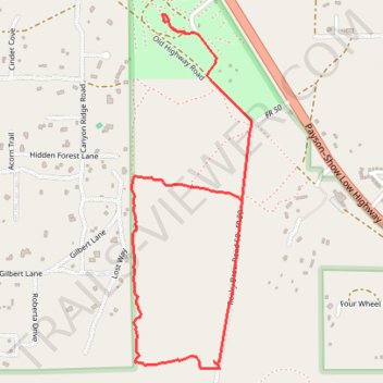
Hiking trails in Tall Timbers
- Distance: 3.6 Km
- Elevation gain: 36 m
- Maximum elevation: 2,048 m
- Elevation loss: 30 m
- Minimum elevation: 2,017 m
- Moving time: 45 m 17 s
- Moving speed: 4.8 Km/h
- Maximum speed: 32.1 Km/h
- Total time: 48 m 24 s
- Global speed: 4.5 Km/h
Interactive trail map
Trail profile
- Distance: 3.6 Km
- Elevation gain: 36 m
- Maximum elevation: 2,048 m
- Elevation loss: 30 m
- Minimum elevation: 2,017 m
- Moving time: 45 m 17 s
- Moving speed: 4.8 Km/h
- Maximum speed: 32.1 Km/h
- Total time: 48 m 24 s
- Global speed: 4.5 Km/h
About this trail
Name: Hiking trails in Tall Timbers trail, distance, elevation, map, profile, GPS track
Start: 18, Navajo County, Arizona, 85933, United States (34.39935 -110.56450)
End: Rocky Draw Road 50, Navajo County, Arizona, 85933, United States (34.39304 -110.56168)
Coordinates: 34.38669 -110.56666 34.40000 -110.56120