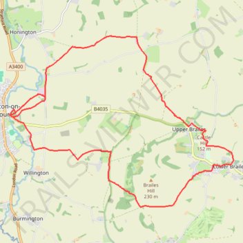
Shipston 🔁 Brailes
- Distance: 19.2 Km
- Elevation gain: 258 m
- Maximum elevation: 182 m
- Elevation loss: 258 m
- Minimum elevation: 62 m
- Moving time: 1 h 59 m
- Moving speed: 9.6 Km/h
- Maximum speed: 17.7 Km/h
- Total time: 1 h 59 m
- Global speed: 9.6 Km/h
Interactive trail map
Trail profile
- Distance: 19.2 Km
- Elevation gain: 258 m
- Maximum elevation: 182 m
- Elevation loss: 258 m
- Minimum elevation: 62 m
- Moving time: 1 h 59 m
- Moving speed: 9.6 Km/h
- Maximum speed: 17.7 Km/h
- Total time: 1 h 59 m
- Global speed: 9.6 Km/h
About this trail
Name: Shipston 🔁 Brailes trail, distance, elevation, map, profile, GPS track
Coordinates: 52.04178 -1.62200 52.07926 -1.54201
Other hiking, mountain biking, running and outdoor activity trails
Click on a trail to view its statistics, map and profile.
Loop from Tysoe via Burdrop and Brailles in The Cotswolds National Landscape
United Kingdom > England > Warwickshire > Stratford-on-Avon > Middle Tysoe
Distance: 25.5 Km • Elevation gain: 459 m • Maximum elevation: 214 m