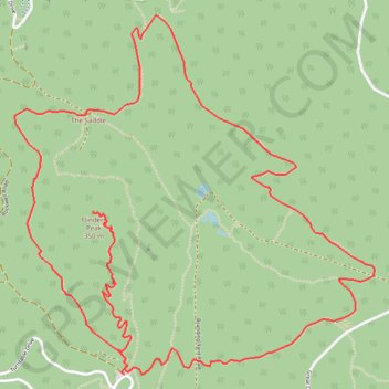
You Yangs Circuit - Flinders Peak
Interactive trail map
Trail profile
- Distance: 10.5 Km
- Elevation gain: 428 m
- Maximum elevation: 335 m
- Elevation loss: 424 m
- Minimum elevation: 66 m
About this trail
Name: You Yangs Circuit - Flinders Peak trail, distance, elevation, map, profile, GPS track
Start: Rockwell Road, Little River, City of Greater Geelong, Victoria, Australia (-37.95905 144.42666)
End: East Track, Little River, City of Greater Geelong, Victoria, 3211, Australia (-37.95861 144.42686)
Coordinates: -37.95906 144.41974 -37.94122 144.44237
Other hiking, mountain biking, running and outdoor activity trails
Click on a trail to view its statistics, map and profile.