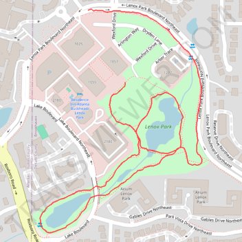
Walk around Lenox Park
- Distance: 2.3 Km
- Elevation gain: 40 m
- Maximum elevation: 291 m
- Elevation loss: 44 m
- Minimum elevation: 271 m
- Moving time: 27 m 6 s
- Moving speed: 5.1 Km/h
- Maximum speed: 9.7 Km/h
- Total time: 27 m 6 s
- Global speed: 5.1 Km/h
Interactive trail map
Trail profile
- Distance: 2.3 Km
- Elevation gain: 40 m
- Maximum elevation: 291 m
- Elevation loss: 44 m
- Minimum elevation: 271 m
- Moving time: 27 m 6 s
- Moving speed: 5.1 Km/h
- Maximum speed: 9.7 Km/h
- Total time: 27 m 6 s
- Global speed: 5.1 Km/h
About this trail
Name: Walk around Lenox Park trail, distance, elevation, map, profile, GPS track
End: 1057, Parkside, Brookhaven, DeKalb County, Georgia, 39319, United States (33.84941 -84.34568)
Coordinates: 33.84575 -84.34817 33.85118 -84.34343
Other hiking, mountain biking, running and outdoor activity trails
Click on a trail to view its statistics, map and profile.
Atlanta, Lilburn, Yellow River Park, Panola, Jonesboro
United States > Georgia > Fayette County > Peachtree City > Stop
Distance: 335.0 Km • Elevation gain: 4,058 m • Maximum elevation: 338 m