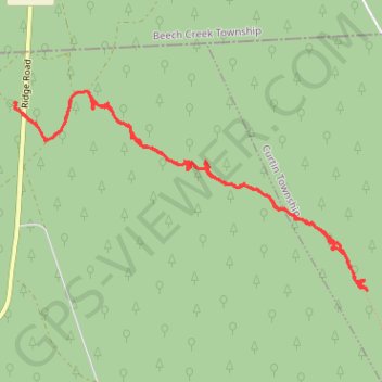
Eddy Lick Trail
- Distance: 8.1 Km
- Elevation gain: 184 m
- Maximum elevation: 675 m
- Elevation loss: 184 m
- Minimum elevation: 533 m
- Moving time: 1 h 51 m
- Moving speed: 4.3 Km/h
- Maximum speed: 35.1 Km/h
- Total time: 2 h 15 m
- Global speed: 3.6 Km/h
Interactive trail map
Trail profile
- Distance: 8.1 Km
- Elevation gain: 184 m
- Maximum elevation: 675 m
- Elevation loss: 184 m
- Minimum elevation: 533 m
- Moving time: 1 h 51 m
- Moving speed: 4.3 Km/h
- Maximum speed: 35.1 Km/h
- Total time: 2 h 15 m
- Global speed: 3.6 Km/h
About this trail
Name: Eddy Lick Trail trail, distance, elevation, map, profile, GPS track
Coordinates: 41.16384 -77.87920 41.17629 -77.84983