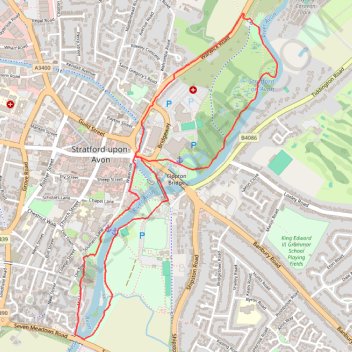
River Avon Loop Walk
- Distance: 5.2 Km
- Elevation gain: 17 m
- Maximum elevation: 43 m
- Elevation loss: 17 m
- Minimum elevation: 35 m
- Moving time: 1 h 2 m
- Moving speed: 5.0 Km/h
- Maximum speed: 8.4 Km/h
- Total time: 1 h 2 m
- Global speed: 5.0 Km/h
Interactive trail map
Trail profile
- Distance: 5.2 Km
- Elevation gain: 17 m
- Maximum elevation: 43 m
- Elevation loss: 17 m
- Minimum elevation: 35 m
- Moving time: 1 h 2 m
- Moving speed: 5.0 Km/h
- Maximum speed: 8.4 Km/h
- Total time: 1 h 2 m
- Global speed: 5.0 Km/h
About this trail
Name: River Avon Loop Walk trail, distance, elevation, map, profile, GPS track
Coordinates: 52.18373 -1.70839 52.19967 -1.69226
Other hiking, mountain biking, running and outdoor activity trails
Click on a trail to view its statistics, map and profile.
Trailrun Stratford-upon-Avon
United Kingdom > England > Warwickshire > Stratford-on-Avon > Stratford-upon-Avon > Tiddington
Morning Run
Distance: 14.0 Km • Elevation gain: 140 m • Maximum elevation: 112 m