Savanna Portage State Park
Aitkin County Running
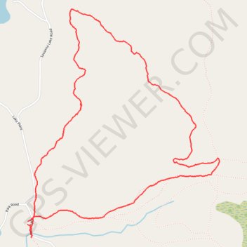
- Distance: 6.1 Km
- Elevation gain: 75 m
- Maximum elevation: 428 m
- Elevation loss: 75 m
- Minimum elevation: 382 m
- Moving time: 58 m 53 s
- Moving speed: 6.3 Km/h
- Maximum speed: 13.1 Km/h
- Total time: 58 m 53 s
- Global speed: 6.3 Km/h
Interactive trail map
Trail profile
- Distance: 6.1 Km
- Elevation gain: 75 m
- Maximum elevation: 428 m
- Elevation loss: 75 m
- Minimum elevation: 382 m
- Moving time: 58 m 53 s
- Moving speed: 6.3 Km/h
- Maximum speed: 13.1 Km/h
- Total time: 58 m 53 s
- Global speed: 6.3 Km/h
About this trail
Name: Savanna Portage State Park trail, distance, elevation, map, profile, GPS track
Start: Lake Place, Aitkin County, Minnesota, United States (46.82885 -93.17751)
End: Lake Place, Aitkin County, Minnesota, United States (46.82864 -93.17752)
Coordinates: 46.82775 -93.17752 46.84336 -93.15835