Cycle routes and some on-road Marriott Hotel to Dragonfly Hotel and back
Hiking route
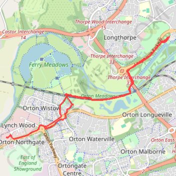
- Distance: 10.9 Km
- Elevation gain: 42 m
- Maximum elevation: 24 m
- Elevation loss: 37 m
- Minimum elevation: 4 m
- Moving time: 32 m 20 s
- Moving speed: 20.2 Km/h
- Maximum speed: 41.3 Km/h
- Total time: 1 h 21 m
- Global speed: 8.0 Km/h
Interactive trail map
Trail profile
- Distance: 10.9 Km
- Elevation gain: 42 m
- Maximum elevation: 24 m
- Elevation loss: 37 m
- Minimum elevation: 4 m
- Moving time: 32 m 20 s
- Moving speed: 20.2 Km/h
- Maximum speed: 41.3 Km/h
- Total time: 1 h 21 m
- Global speed: 8.0 Km/h
About this trail
Name: Cycle routes and some on-road Marriott Hotel to Dragonfly Hotel and back trail, distance, elevation, map, profile, GPS track
Coordinates: 52.54987 -0.32461 52.57145 -0.26806