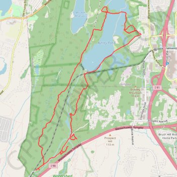
Ashley Watershed and Watershed Land Loop
- Distance: 14.5 Km
- Elevation gain: 154 m
- Maximum elevation: 132 m
- Elevation loss: 154 m
- Minimum elevation: 79 m
- Moving time: 1 h 32 m
- Moving speed: 9.4 Km/h
- Maximum speed: 32.2 Km/h
- Total time: 1 h 33 m
- Global speed: 9.3 Km/h
Interactive trail map
Trail profile
- Distance: 14.5 Km
- Elevation gain: 154 m
- Maximum elevation: 132 m
- Elevation loss: 154 m
- Minimum elevation: 79 m
- Moving time: 1 h 32 m
- Moving speed: 9.4 Km/h
- Maximum speed: 32.2 Km/h
- Total time: 1 h 33 m
- Global speed: 9.3 Km/h
About this trail
Name: Ashley Watershed and Watershed Land Loop trail, distance, elevation, map, profile, GPS track
Start: Whitney Avenue, Holyoke, Hampden County, Massachusetts, 01040, United States (42.17442 -72.65099)
End: Whitney Avenue, Holyoke, Hampden County, Massachusetts, 01040, United States (42.17446 -72.65103)
Coordinates: 42.14334 -72.68356 42.18083 -72.65099