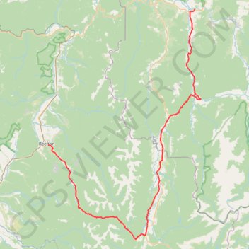
Murchison - Reefton
#Bike
- Distance: 122.2 Km
- Elevation gain: 1,826 m
- Maximum elevation: 689 m
- Elevation loss: 1,797 m
- Minimum elevation: 169 m
Interactive trail map
Trail profile
- Distance: 122.2 Km
- Elevation gain: 1,826 m
- Maximum elevation: 689 m
- Elevation loss: 1,797 m
- Minimum elevation: 169 m
About this trail
Name: Murchison - Reefton trail, distance, elevation, map, profile, GPS track
Start: Riverview Holiday Park, Riverview Road, Murchison, 7007, New Zealand (-41.79565 172.34090)
End: 14, Broadway, Reefton, Buller District, West Coast, 7830, New Zealand (-42.11981 171.86990)
Coordinates: -42.34506 171.86990 -41.79520 172.35985
Other hiking, mountain biking, running and outdoor activity trails
Click on a trail to view its statistics, map and profile.
Globe-Progress Gold Mine Loop MTB from Reefton via Zig Zag Track, Globe Hill Trail and Soldiers - Big River Road
New Zealand > West Coast > Buller District
Distance: 24.6 Km • Elevation gain: 957 m • Maximum elevation: 628 m